


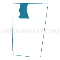
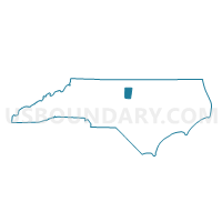
Voting District CG, Orange County, North Carolina
About
Outline

Summary
| Unique Area Identifier | 641055 |
| Name | Voting District CG |
| County | Orange County |
| State | North Carolina |
| Area (square miles) | 27.22 |
| Land Area (square miles) | 26.65 |
| Water Area (square miles) | 0.57 |
| % of Land Area | 97.92 |
| % of Water Area | 2.08 |
| Latitude of the Internal Point | 36.18770390 |
| Longtitude of the Internal Point | -79.16401910 |
Maps

Graphs
Select a template below for downloading or customizing gragh for Voting District CG, Orange County, North Carolina


Neighbors
Neighoring Voting District (by Name) Neighboring Voting District on the Map
- Voting District BFRK, Person County, NC
- Voting District CA, Orange County, NC
- Voting District CP, Orange County, NC
- Voting District CX, Orange County, NC
- Voting District EF, Orange County, NC
- Voting District HUML, Person County, NC
- Voting District PROS, Caswell County, NC
- Voting District TO, Orange County, NC
- Voting District WH, Orange County, NC
Top 10 Neighboring County Subdivision (by Population) Neighboring County Subdivision on the Map
- Hillsborough township, Orange County, NC (13,809)
- Cheeks township, Orange County, NC (9,313)
- Cedar Grove township, Orange County, NC (5,222)
- Bushy Fork township, Person County, NC (2,516)
- Hightowers township, Caswell County, NC (1,773)
Top 10 Neighboring Unified School District (by Population) Neighboring Unified School District on the Map
- Orange County Schools, NC (49,938)
- Person County Schools, NC (39,464)
- Caswell County Schools, NC (23,719)
Top 10 Neighboring State Legislative District Lower Chamber (by Population) Neighboring State Legislative District Lower Chamber on the Map
Top 10 Neighboring State Legislative District Upper Chamber (by Population) Neighboring State Legislative District Upper Chamber on the Map
Top 10 Neighboring 111th Congressional District (by Population) Neighboring 111th Congressional District on the Map
Top 10 Neighboring Census Tract (by Population) Neighboring Census Tract on the Map
- Census Tract 109.01, Orange County, NC (5,383)
- Census Tract 108.01, Orange County, NC (5,025)
- Census Tract 9306, Caswell County, NC (4,790)
- Census Tract 108.02, Orange County, NC (4,654)
- Census Tract 9206.02, Person County, NC (4,619)